
Rural tourism is the form of tourism that focuses on rural sites highlighting the rural art, culture, heritage and lifestyle, thereby strengthening the local economy and enabling social and cultural exchange. More than 75 percent of Indian population lives in the village and according to Census report 2011 there are 63,8691 villages in India and total rural population is 741,6,60,293 with an average population of 1,161 per village. The rural tourism destinations have huge potential to turn into important tourist centers. Scenic beauty including rivers, forests, mountains, paddy field and lakes, valuable heritage, rich historical legacy, and traditional culture; these rural hoard of treasure helps in the growth of Rural Tourism. But lack of detail information about the locations and related infrastructures is acting as barrier in this transition. The tourism industry has widely adopted Information Technology (IT) to provide improved service and information to the tourists. Geospatial Mashups is the process of merging multiple sources heterogeneous data, both spatial and non-spatial, into a single integrated spatial display. These Geospatial applications are increasingly becoming critical for the competitive operations of the tourism destinations as well as hospitality organizations. The present study discusses about the architecture and the strategic application of Geospatial Mashups in tourism development and promotion.
Implications of Geospatial Mashup at Kamarpukur Tourism:
This rural tourism site is gaining popularity. Initially, the place was popular only among the local areas or, at most to the people of West Bengal. But slowly the popularity of the philosophic thoughts of Sri Sri Ramakrishna has reached to every corner of India and has influenced and attracted people from different countries too. People from different parts of the world might be eager to visit this place of interest. But very little information about the location has been provided in the existing online Mashup maps. Information like how to reach from nearby towns, available transports, hotel information, is there banking service nearby for easy monetary transactions etc. are still lacking. Related to tourism promotion information about other cultural or pilgrimage location nearby are still very local. The lack of above-mentioned information for potential tourists is clear if we check available map applications offered by larger corporations, such as Google Maps. Figure 1 depicts available online information on Kamarpukur in Google Earth Pro application.
Source: Retrieved from Google Earth (www.google.com/maps)
Figure 1: Existing Online Map of Kamarpukur Area
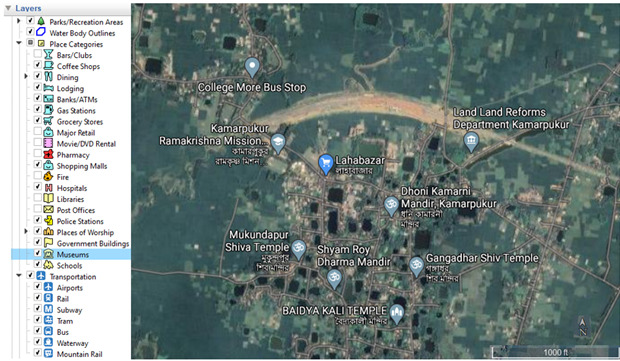
On the left-hand tab of Figure 1 most of the essential tourism related Mashup features like, information about hotels, gas-stations, museums, places of worship etc. are made active to depict the detail information about the locality in and around Kamarpukur. But still spiritual places of interest like Laha’s Durga Temple, Gopeswar Shiv Temple, and Room of Sri Sri Ramakrishna are missing. On the other hand, places where the tourists can enjoy the rural nature like the Bhutir Khal (Canal Water body), Haldar Pukur (Lake), Playground near Bhutir Khal etc. are missing. So, it is providing limited spatial information of Kamarpukur, the connecting roads and only a few information about the hotels or restaurants available. It doesn’t provide additional information about other cultural or heritage centre. A proposed Mashup map (Figure 2) has been used to integrate the places of interests in and around Kamarpukur that are missing in the current available online map. Figure 2 has been designed using open source Google Earth Pro application. Proposed tourist sites are identified keeping in mind the potential tourists who want to enjoy the rural nature together with spiritual and cultural flavor of Kamarpukur.

Source: Designed using Google Earth (www.google.com/maps)
Figure 2: Proposed Map of Places of Interest in and Around Kamarpukur
If these additional locations are available online in the Mashup maps the participatory clients like local hotel or restaurant owners or local tourism agents can perform some geo-spatial processing tasks. It is growing every day, every month and every year with a steady pace. West Bengal is a state with a dominant tourism destination. So, rural tourism destination development can be of great importance here. The simplicity of rural living, the timelessness of rural landscape is something unique and unexplored in this part of the state. If a proper marketing/ promotional plan is done for rural tourism destination in West Bengal in general and concerned districts in particular, it could bring a lot of benefit to this state.
Contributors of this Blog :
Nilanjan Ray. PhD
Associate Professor of Marketing Management
School of Management
Adamas University
Mr. Somnath Chaudhuri, (MTech)
Research Fellow, Erasmus Mundus
Universitat Jaume I, Spain
Ms Tanisha Mukherjee,(MCom)
MBA 1st Year Student
School of Management
Visited 2464 times, 1 Visit today